• English

THiNKNET Co., Ltd. (Head Office)
323 United Center Building, 6th Floor, Room 601,
Silom Road, Silom, Bangrak, Bangkok 10500

www.thinknet.co.th0 2480 9990sales@thinknetdesign.studio@thinknetdesign
All Products

EDUCATION

Science

Mathematics

Language and Communication

Social Studies

Arts

General Knowledge

Accessories

BUSINESS MAPS

Bangkok

Thailand

Book

Folded

DECOR

Map

View

Nature

Science

Feng Shui

Abstract

Digital Art

Artist Collection

Copyright © 2025 THiNKNET Co., Ltd. All Rights Reserved.

Terms of Use | Disclaimer | Cookie Policy
  1. HOME
    • EDUCATION
  2. Social Studies
  3. Physical Map of South Asia
ED_Sheet_Paper-1

Physical Map of South Asia

Maps & Educational Materials
THB 449 - 4,999

Design:
Product Details
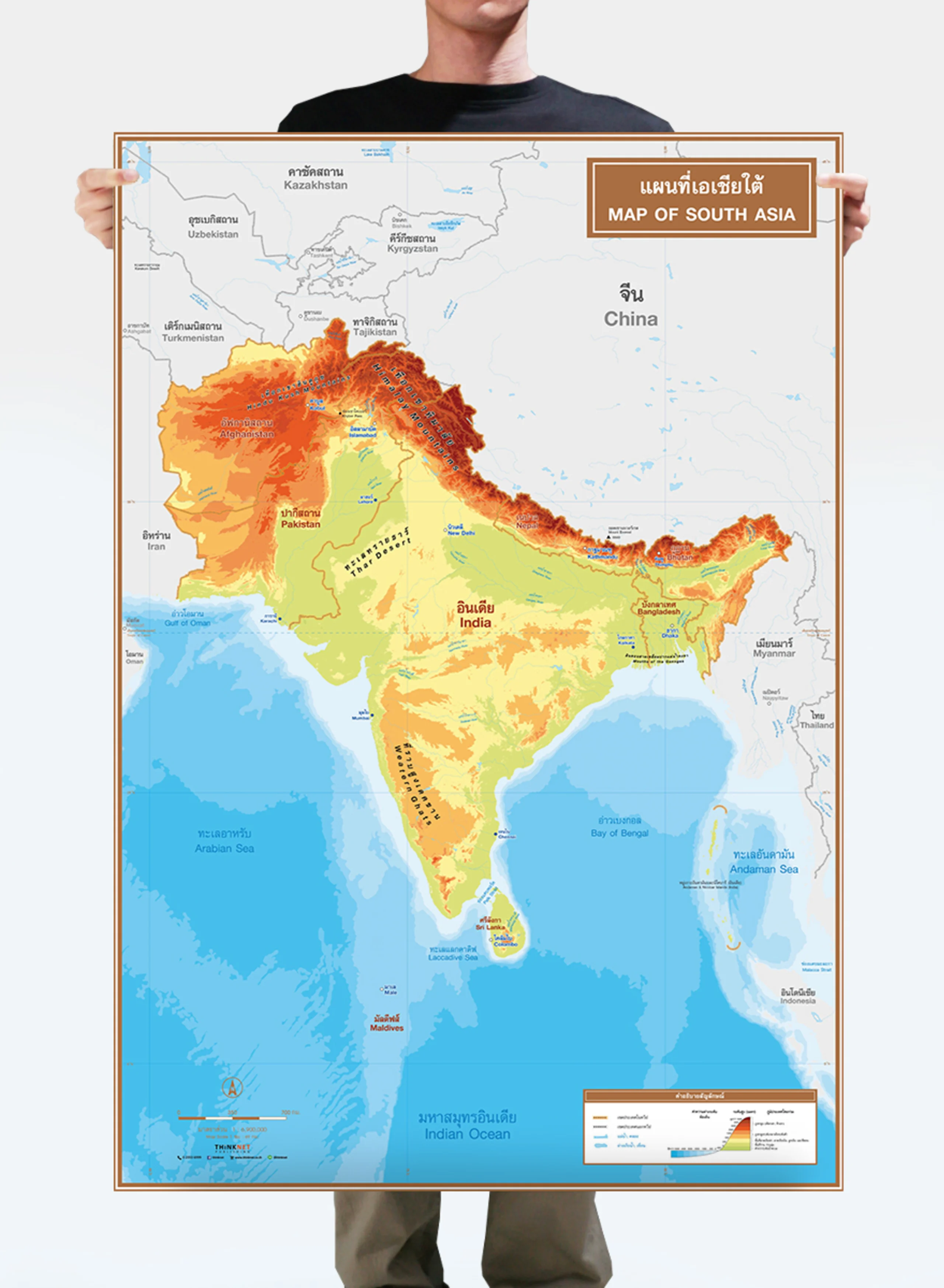
Physical map of South Asia.

• Shows 5 countries in Southwest Asia: Afghanistan, Pakistan, India, Bangladesh, and Bhutan.
• Shows the governmental boundaries of each country and territory borders with neighboring countries.
• Shows capital cities.
• Shows geographic information: mountain ranges, plains, main rivers, straits, lakes, deserts, islands, archipelagos, gulfs, seas, and important oceans.
• Shows geographical features in different colors based on the elevations and depth of the seas.
• Shows the height of the important peaks.
• Bilingual: Thai-English.
• 2023 updated.
• Size (M) 69x100 cm has a scale of 1:6,900,000, size (XL) 100x138 cm has a scale of 1:4,900,000.
• Suitable for senior high school students age 15-17 years old.

PRODUCTS YOU MAY BE INTERESTED IN

Physical Map of Central Asia

Physical Map of Central Asia

THB 449 - 4,999

Political Map of Australia and Oceania

Political Map of Australia and Oceania

THB 449 - 4,999

Political Map of Asia

Political Map of Asia

THB 449 - 4,999

Physical Map of Southeast Asia

Physical Map of Southeast Asia

THB 449 - 4,999

Political World Map: Orthographic Projection

Political World Map: Orthographic Projection

THB 449 - 4,999